Visit North Idahohomepage North Idaho Tourism logo

Hiking Trails Through Northern Idaho: The Northwest’s Playground

wavey lines

Northern Idaho is full of scenic routes for hikers to enjoy. Explore lush forests, pass through verdant valleys, and discover secret waterfalls. Delight in eye-catching sights seen only on Northern Idaho trails. Along with stunning landscapes to explore, the best hikes in Idaho cater to a wide range of experience levels — check out these 23 trails and start planning your next outdoor adventure today.

Easy Trails
A couple stands on a rocky alcove overlooking Coeur d’Alene Lake from Tubbs Hill Nature Trail in Coeur d’Alene, Idaho.

Tubbs Hill Nature Trail

A wooden sign that reads “Brickel Creek Walking Trail” stands in the foreground, with hikers seen along the trail in the background near Spirit Lake, Idaho.

Brickel Creek Walking Trail

A group of 20 plus hikers are seen hiking through a wooded forest along the Pine Street Woods trails in Sandpoint, Idaho.

Pine Street Woods

Shadow Falls Trail #513

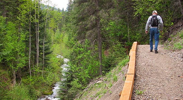
Shadow Falls Trail #513 is the ultimate place to start your Northern Idaho exploration. This short and sweet trail is only 0.6 miles long, and offers visitors a seasonal view of multiple area waterfalls. Located just outside Wallace, Idaho in Silver Valley awaits a beautiful, peaceful, and well-maintained trail with handicap accessibility along the first portion of the path. Follow split log footbridges over babbling brooks through lush forest to the 25-foot-tall Shadow Falls, or hike a bit further to see its smaller counterpart, Fern Falls. This trail is a short jaunt to big scenic payouts — perfect for family expeditions.

Directions: There are two access points, one from heading east from Coeur d’Alene, Idaho, and the other heading north from Wallace, Idaho. The road leading to this trailhead is accessible to all vehicles and is well maintained.

Granite Falls Trail

Discover an area of old-growth cedar forest 14 miles north of Nordman, Idaho. The Roosevelt Grove of Ancient Cedars Scenic Area, named for former President Theodore Roosevelt, offers visitors a chance to walk among virgin forest. With trees up to 12 feet in diameter, 150 feet tall, and some as old as 2,000 years, there’s no better place to get lost in the grandeur of Northern Idaho’s stunning forests. Take the Granite Falls Trail #301 several hundred feet from the parking lot and get a view of the Lower Falls cascading over sheer rock walls. Follow the entire 1.1-mile-long loop to catch views of both the Upper and Lower Falls.

Directions: From Nordman, Idaho head north 25 minutes to The Roosevelt Grove of Ancient Cedars Scenic Area, and from there follow the signs to the Granite Falls trailhead.

Tubbs Hill Nature Trail

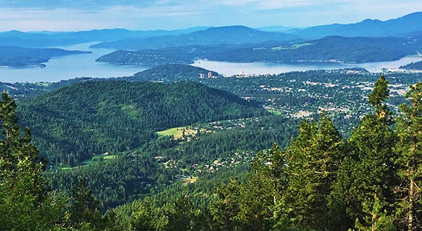
Traverse through the heart of downtown Coeur d’Alene along the Tubbs Hill Nature Trail for Instagram-worthy views of the city. Open year-round and consisting of over 120 acres that border Lake Coeur d’Alene, this 2-mile loop is an awesome way to experience Northern Idaho’s flora and fauna without straying too far from home base. Pack a picnic and bring the family to enjoy stunning views of both the city and nearby nature.

Directions: This trailhead is located in the southwestern corner of McEuen Park parking lot in Coeur d’Alene, Idaho.

Robinson Lake Trail

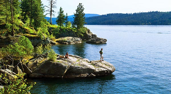
Visit the 2.7-mile Robinson Lake Trail for a hike along a scenic interpretive loop. Located 25 miles north of Bonners Ferry and open year-round, the Robinson Lake Trail is a suitable hike for all experience levels. Pass through streamside and lakeshore habitats and view the abundant regional wildlife that inhabits the park. Pack a picnic, take a dip, or drop a line after your hike to enjoy continued use of the Robinson Lake Campground.

Directions: Travel north from Bonners Ferry 30 minutes to arrive at the Robinson Lake Campground. Please note that day use of the area is free, but there’s a $15 fee for overnight campers.

Brickel Creek Trail

Hike to some of Spirit Lake, Idaho’s most exclusive, unknown, and pristine waterfalls. Follow the Brickel Creek Trail and traverse through 5 miles of wild woods, with giant boulders and rushing creeks. Follow this local favorite trail all the way to the end to experience hidden waterfalls throughout. Open seasonally, this wide and well-maintained trail makes for the perfect summer hike.

Directions: Though finding this trailhead can sometimes prove tricky, the drive is well worth the payout. From Spirit Lake, follow Maine Street due west until it turns into West Spirit Lake Road. Follow this road until it turns to gravel and you encounter a host site. Entrance to the park and campground are $15 per car. Buy your pass from the site host, and they’ll lead you to the Brickel Creek Trailhead.

Pine Street Woods

The Pine Street Woods trail system is a network of some of Northern Idaho’s best hiking trails. Explore over 180 acres of rolling hills and healthy woodlands in this community forest. Located just outside Sandpoint, Idaho, Pine Streets Woods is a local favorite. Though these trails are ideal for hiking, bikers, snowshoers, and nordic skiers are also known to frequent this area. Check out the Sherwood Forest Trail, Pipeline Trail, or Bier Bridge Loop to start.

Directions: From Sandpoint, Idaho travel eight minutes west to arrive at the Pine Street Woods parking lot. From there, choose from any number of trails to enjoy.

Falls Park Overlook Trail

The Falls Park Overlook Trail is a 0.3 mile heavily trafficked loop trail located near Post Falls, Idaho that features a waterfall and is good for all skill levels. The trail is primarily used for hiking and walking and is best used from March until November.

Directions: located in Post falls, ID off of 4th Ave.

Black Bay Park Trail

The Black Bay Park Trail is a 0.6 mile moderately trafficked loop trail located near Post Falls, Idaho that features a lake and is good for all skill levels. The trail offers a number of activity options and is best used from April until November. Dogs are also able to use this trail but must be kept on leash.

Directions: located in Post falls, ID on N Bay St.

Share Share on Pinterest
Moderate Trails
A couple is seen ascending the Q’emiln Park Trail in Post Falls, Idaho.

Q’emiln Park

A single hiker traverses a narrow path parallel to a creek on the Pulaski Tunnel Trail in Wallace, Idaho.

Pulaski Tunnel Trail

Views overlooking mountainous forests and lakes along the Canfield Mountain Trails near Coeur d’Alene, Idaho.

Canfield Mountain Trails

Q’emiln Park

Located five minutes south of Post Falls, Idaho is Q’emiln Park (pronounced “ka-mee-lin) This 79-acre, multi-use forested area is surrounded by Spokane Riverfront, granite cliffs, and native wildlife. Open for non-motorized public recreation, Q’emiln park is a great place to play. Take the Old Wagon Loop to Spokane River Trail for a 2.2-mile, moderate hike through the Post Falls area.

Directions: From Post Falls, Idaho head five minutes south to Q’emiln Park. From the park parking lot, explore numerous opportunities for outdoor recreation.

Schweitzer Mountain

Schweitzer Mountain Resort offers hikers and runners a number of easily accessible and well-maintained trails. Whether you want a leisurely stroll, or an intense workout, Schweitzer Mountain has something for everyone. Take the chairlift to the top of the mountain and enjoy breathtaking panoramic views on one of the multiple peak side loops. Alternatively, guests can skip the chairlift entirely and follow the 2.5-mile nature trail to the top. Whatever your speed, enjoy access to over 20 miles of pristine trails perfect for hiking, trail running, photography, bird watching, and even huckleberry picking in the summer months.

Directions: From Sandpoint, Idaho travel northwest 30 minutes to Schweitzer Mountain Resort. Onsite staff can direct which trails to take from there.

Mineral Ridge National Recreation Trail

Looking for a trail that leads you through Coeur d’Alene bays? The Mineral Ridge National Recreation Trail is an outstanding 3.3-mile, moderate hike through the Beauty and Wolf Lodge bays of Coeur d’Alene. Established by the Bureau of Land Management in 1962, this trail has been a community staple for decades. Follow 22 interpretive signs along the well-maintained trail to learn about indigenous plants and animals. Explore the interrelationships of the nearby city and regional forest through the Mineral Ridge Trail.

Directions: Travel 15 minutes south from Coeur d’Alene, Idaho to the Mineral Ridge Scenic Area parking lot. Open to the public year-round, this trailhead is well-marked and includes visitor picnic tables, pit toilets, and trash receptacles.

Pulaski Tunnel Trail

Hike the historical Pulaski Tunnel Trail and learn about the great fires of 1910. Located 10 minutes from downtown Wallace, Idaho, the Pulaski Trail is a 4-mile-long trail that leads hikers through an area once ravaged by fire. The site’s harsh history is only felt, not seen, however, as the nearly 100 years of reforestation have left the region cloaked in a thick jacket of spruce and fir trees.

Directions: Head six minutes south from Wallace, Idaho to the Pulaski Tunnel Trailhead. Allow two to four hours for the four-mile round trip to the Pulaski Tunnel overlook.

Roman Nose Lakes Trail

Explore the Roman Nose Lakes Trail for a 4.1-mile, moderately trafficked hike. Open during the summer and fall months, the Roman Nose Lakes Trail is an excellent area for hiking, as well as, picnicking, fishing, camping, and huckleberry picking. Follow the interpretive trail signs to upper, middle, and lower Roman Nose Lakes. Enjoy breathtaking views from numerous overlooks.

Directions: From Bonners Ferry, Idaho, travel one hour west to the Roman Nose Lakes. When traveling to this trail, note that the road there is accessible to all vehicles, but AWD vehicles are recommended.

Canfield Mountain Trails

For a more advanced hike, take Canfield Mountain Trails 1562, D, and Loop 3. Open to the public year-round, this 5.3-mile loop offers some of Northern Idaho’s most stunning views of local wildflowers in the spring. Though the trail poses some challenges throughout its terrain, the views are well worth the workout. Pack up your pups, and hit the trail.

Directions: From downtown Coeur d’Alene, Idaho head 10 minutes north to the Canfield Mountain Trailhead.

Marie Creek Trail

Located 20 minutes outside Coeur d’Alene, Idaho, the Marie Creek Trail is an excellent 8.7-mile out-and-back hike. Walk along the river and enjoy year-round access to Northern Idaho’s verdant forests and meadows. Bring the pup, and enjoy numerous opportunities to take a dip in the summer months.

Directions: From Coeur d’Alene, Idaho drive 20 minutes east to the East Marie Creek Road access point. Follow signage from there.

Section 16

Open to the public year-round, Section 16 is composed of two moderate trails, and is curated in conjunction with the Idaho Department of Lands and Boundary County and 9B Trails. Mix and match trail combinations to add terrain variety and length to your hike. Explore up to 11 miles of the Kootenai Valley along these all-access trails. Open year-round and located in the beautiful Paradise Valley just outside Bonners Ferry, this trail is ideal for both novice and experienced hikers.

Directions: Head 10 minutes south Bonners Ferry to Kootenai Trail Road. Follow signage from there.

Green Monarch Ridge

Green Monarch Ridge to Green Monarch Mountain is a 5.6 mile moderately trafficked out and back trail located near Hope, Idaho that features a lake and is rated as moderate. The trail offers a number of activity options and is best used from May until October. Dogs are also able to use this trail.

Directions: 45 minutes southwest of Hope, ID

Share Share on Pinterest
Advanced Trails
Italian Ridge to Shorty Peak Lookout

Situated among the American Selkirk mountain range, Italian Ridge is a 2.6-mile advanced hike that leads to Shorty Peak Lookout. Enjoy panoramic views of Kootenai River Valley and the Purcells from atop the 6,500-foot Shorty Peak. Open to the public in the summer and early-fall months, Italian Ridge offers an intense uphill workout surrounded by stunning views, fir forest, indigenous wildlife, and babbling springs.

Directions: From Bonners Ferry head northwest an hour. Follow USFS signage from Smith Creek Road to trailhead #95 (AKA Italian Ridge).

Mickinnick Trail

Follow 3.5-mile out-and-back Mickinnick Trail for a challenging workout. Totaling 7-miles in length, this trail ascends over 2,000 feet through huge rock outcroppings, grassy meadows, open forests, and steep switchbacks. Summit the mountain and experience stunning panoramic views of Sandpoint, the Long Bridge, the Cabinet Mountains, and Lake Pend Oreille.

Directions: From Sandpoint head 10 minutes north to the Mickinnick Trailhead.

Scotchman Peak Trail

Scotchman Peak Trail is a popular advanced trail located near Sandpoint. Open during the summer months, there’s no better place to experience views of Lake Pend Oreille and the Clark Fork River Valley than along this hike. Follow the trail up a steep and steady incline along this 7.6-mile out-and-back trail. Please note that weather and trail conditions are subject to change — and frequently do. Prepare accordingly, and the payout is huge. This high country trail is a rewarding workout with stunning views (and sometimes, if you’re lucky, you can see firsthand the family of mountain goats that call this summit home).

Directions: From Sandpoint head 45 minutes east to Scotchman Peak Trailhead.

Arid Peak Lookout via Slate Creek Divide

Arid Peak via Slate Creek Divide is a 13.7 out and back trail located just outside of Avery. This lightly trafficked trail offers an intense uphill climb to the Arid Peak Lookout – a former 1930s United State Forest Service fire lookout. Pass through alpine forests and through granite outcroppings on this intensely rewarding trail.

Directions: From Kellogg head southeast toward National Forest Development Road 389 and follow signage to the trailhead.

Springston Trail

Get a bird’s eye view of the Coeur d’Alene River, Thompson Lake Wildlife Refuge, and Anderson Lake on this steep hike near the Trail of the Coeur d’Alenes Springston Trailhead. The trail is primitive, free, and not signed.

Directions: To drive there from Harrison, head north on Hwy 97 and cross the bridge two miles from town. Turn right onto Blue Lake Rd. after the bridge. From there it’s 1.8 miles east to Springston Bridge. Turn right over the bridge to the trailhead parking area. Walk toward Anderson Lake on the dirt road and look for a trail on your left that leads uphill. Follow it around to the right for a good climb.

Stevens Lakes Trail

Stevens Lakes Trail is a 5 mile heavily trafficked out and back trail located near Mullan, Idaho that features a lake and is rated as difficult. The trail offers a number of activity options and is best used from June until October. Dogs are also able to use this trail but must be kept on leash.

Directions: From Mullan, ID take Friday Ave east till it forks take the right that becomes Willow Creek that turns into National Forest Road 8008 and follow signage to the trailhead.

Share Share on Pinterest
wavey lines

Whether you’re in the market for a laidback stroll through secluded parks or long hikes through picturesque scenery, Northern Idaho has a hike suited for every experience level and type of hiker.