Trail of the Coeur d’Alenes
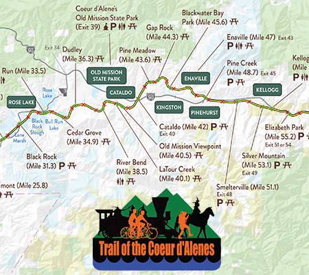
The Trail of the Coeur d’Alenes bike path follows the Union Pacific Railroad right-of-way from Mullan, a mountain mining town near the Montana border, to Plummer, a town on the prairie near the Washington border, offering one of the premier rails-to-trail routes in the Pacific Northwest.
Click for downloadable Interactive Map»
More than 72 miles of paved path takes you from high mountain splendor, through the historic Silver Valley, into the chain lakes region, along the shore of Lake Coeur d’Alene, over the Chatcolet Bridge to Heyburn State Park, and finally climbs to the Palouse prairie: an adventure for the entire family! The Trail of the Coeur d’Alenes is a year-round recreational opportunity. The trail, restrooms and wayside rest stops along its length, are routinely cleaned. The trail is beautifully maintained by Idaho Parks and Recreation and Coeur d’Alene Tribe. Many miles of private land are adjacent to the trail corridor. Please stay on the trail to respect landowners privacy.
Group and Special Events please contact the trail rangers at 208-682-3814.
More information
Interactive Trail Map
Trail of the Coeur d’Alenes